What's new in beta version? What's next?
Done and in the queue for version 1.8:
### Support for iOS 11 beta users (released in beta #36, July 1, 2017) ###
There are some breaking changes in iOS 11 beta 1 and 2 compared to iOS8-10. Beta #36 addresses them and I’ll test/update continuously with new iOS 11 betas as they arrive. If you find any issue while running the beta app on iOS11 beta, please let me know.
### Conclusion of land nav features iteration for year 2017 (released in beta #34, June 19, 2017) ###
Import existing mbtiles, Rmaps, sqlitedb maps
Overview of all land nav additions in beta #34 (points to Compass 55 version 1.8 page).
### Screen or Camera Flash speed limit alert options. (released in beta #29, Mar 7, 2017) ###
If speedometer’s sound alert is not loud enough for you, here are more visual options to alert you when over the limit. “Advanced Settings” > “Flash alert”:

### BMW test pilot mode. Idle/moving time, average speed monitor and alert. (released in beta #28, Mar 4, 2017) ###
When you can’t stop for longer then for X minutes at once and constantly have to monitor idle/moving times, average speed and distance passed - You are probably a rally driver or a test pilot for BMW :). Then this is the mode for you:
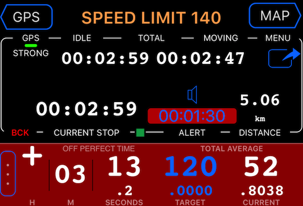
Simply do MENU > MODES and pick “BMW test pilot” mode at the bottom.
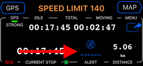
In this mode, TIME panel shows idle/moving time monitor and allows to setup the current stop duration alert. By default, alert is disabled. Tap on a @"——-" button above the ALERT label in the time dash to open the alert settings:
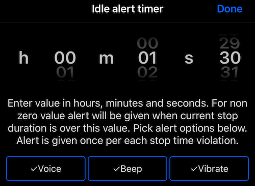
You can setup both the alert timer and options for alerting as Voice, Beep or Vibrate:
Return back to the main screen and now, whenever you stop for longer than the idle alert threshold, you’ll bee notified by a beep, voice message or vibration.
Off road route navigation with voice guidance and off course hints (released in beta #25, Feb 19, 2017)
What started as a simple GPX route import ended up in a route planning on the map and navigating along it with voice directions and hints when you are off the expected course. I could not just stay at shallow “imported!” and then what? This is not a road turn by turn navigation though. This goes by “lines” not the roads between route points. As automatic tracking was and is in the queue before the road turn by turn, it will be implemented first and then I’ll return back to the road based turn by turn.
Here is a video review of how this off road navigation works:
While staying at beta in speedometer until the release with automatic tracking is ready, this off road route navigation will be publicly released in our outdoor navigation app - Compass 55 around Feb 23rd, 2017.
You’ll find many more changes in this beta:
- Menus have been reworked so all of the options are always visible and you don’t need to scroll to see all of the options - means better safety.
- Location and waypoint sharing now works better for sharing via Viber, Facebook and all others.
- Waypoints list now features “filter by collection” or “All” options.
- You can search by address or coordinate on the main map screen, just cancel the centering by the “follow me/not” button.
- Waypoint collection of type “route” has been added and you can now plan your trip/route on the main map, seeing its total distance and the next leg length.
Night mode for the Google map (released in beta, Oct 25, 2016)

**###
Color coded waypoints (released in beta, Nov 2nd, 2016)
###**
**
 **
**
You can set default waypoint color on the whole collection:

In the collection list this default color is shown as a small colored “stripe” on the left:

Color can be overwritten for each waypoint in the waypoint editor:

Or you can revert to the default collection color here as well.
**###
Adding timestamp to the export files (released in beta, Nov 2nd, 2016)
###**
Request came from Jim and it’s definitely a great idea helping to avoid overwriting export files by accident. Now timestamp with date of export is appended to every output file name:
**
 **
**
### Save/Export trips and tracks directly to dropbox or iCloud drive (released in beta, Nov 2nd, 2016) ###
New “Save file” option in trip/track export:

That gives you options to save the export file directly to Dropbox, iCloud drive (or even your mac via airdrop):

### GPX/KML waypoints export (in addition to current different csv formats). Released in beta, Nov 9nd, 2016 ###
**
 **
**
### KMZ/KML waypoints EXPORT so waypoints' images and audio can be exported as well packed into the single KMZ (beta #25 - 22-Dec-2016) ###
Open the list of existing collections:

Tap on a settings button on a row with a collection you want to export and use the “action” button:

Choose “Export” action and pick the desired export format:

Once you pick the row with the target export format, “Email” and “Save” options will appear. “Email” option will add the export file to the email as an attachment. “Save” provides options to save the export file to iCloud drive, Dropbox, Google drive and any other “drive” for which you might have the corresponding “drive” app installed. If you have airdrop on your Mac enabled, it will appear there as well. Here is an example from my iPhone:

### IMPORT tracks and waypoints from GPX files (beta #25, 22-Dec-2016) ###
App offers 3 options for the GPX import:

- Waypoints.
Will import all waypoints inside the GPX <wpt> tags into a single new collection with name corresponding to the import file name. - Tracks.
Will import all tracks inside the GPX <trk> tags into a single new trip with name corresponding to the import file name. Each track is imported as a separate track inside the trip. - Waypoints and tracks.
Takes care of all waypoints and tracks inside the file. All waypoints will go into 1 new collection and all tracks will go into one new trip, each track will be imported as a separate track.
If everything goes alright, you’ll see the import completion dialog:

If there is any problem with the file format or content, the app will tell you :). You can always use a star button on the main screen to email me if you find something missing or not working properly.
Here is an example of how the imported tracks may look:

or waypoints:

Huge thanks to Harrison for the plenty of test GPX data provided based on his crawling through the New Zealand forests (and for the permission to use screenshots with them on this site).
### Coordinate, distance and heading tools for the “don’t follow me” map mode (beta #25, 22-Dec-2016) ###
By default map follows your location and rotates so top of the map always shows ahead of you. You can cancel that by tapping on a “follow or not” button:

When map centering is off, red arrow appears pointing to a map center and toolbar is shown at the map bottom:

#1 - Coordinate the red arrow points to.
#2 - Heading of the red arrow. When map is setup to point always to North, still “rotate” the map and arrow will change its heading.
#3 - Distance between the arrow head and the current location.
#4 - Plus button to add waypoint at the place the red arrow points to.
This way you can check the heading of any building front or highway/road, measure the distance between you and point on a map and see coordinates of any point. If you want to navigate or share this coordinate, just tap on a plus button and waypoint editor will have all these options for you.
All functions above are already released in beta version. How to join beta testing
Here is what is being cooked
Right now:
-
Automatic tracking.
-
Tags on trips and tracks.
-
Monthly stats (also as infotainment). Mileage by year/season/month/week or tag.
-
Offline maps from .sqlitedb and .mbtiles files.
-
KMZ waypoints IMPORT so waypoints' images can be imported.
-
Time limited speed limit signs
Second wave:
-
OBD2
-
My suggestion would be if it could be possible to automatically upload the black box logging in regular times to e.g Dropbox folder. (Stefan via email)
-
0-X timer
-
Land meter. Indicates the angle of car slope or tilt — pitching and rolling
-
Lean angle for bikers
-
Turn by turn navigation - online Apple. Many, many +1s.
-
Own vector maps
-
Apple watch app
-
Graphs
Repository of ideas to grab from
Small to mid size items
-
Indicator to show if you are going up or down. Maybe having elevation green if ascending and red if descending (Cannery rogue via review).
-
I love this app! It has all I need for driving at quick glance/ touch as I trek across the state and back to visit my fiancée doing her residency. The full screen map mode is my favorite with the music controls on the side. My suggestions would be, in order of importance. 1) Please have the option to put the map in a true night mode, not just make it dimmer. See how Google Maps does it for reference. 2) In full screen map mode please give the option to adjust the size of the speed. It is a bit small now, so a few options would be nice. 3) Again in full screen map mode, if I could move the music controls to either the bottom or the right side I’d be very happy. (AtHiggins via review)
-
I want to be able to record on camera at the same time with the GPS in speed (Garry via email)
-
Choose the default view to the initiation of the application …. the top would have a speed limit database and to link alerts to the database (with% in user choice ). (With manual selection maintains the view). michel.dani23 via review (French AppStore)
-
Analogue speedometer with adjustable top speed (Zach Grasley via review)
-
Hi Stan, I hope u don’t mind but I have come up with a new suggestion that may make Speedometer very appealing to car enthusiasts like myself. Adding a dyno bhp graph functionality. You have everything you need, the starting speed, input a few things about the car weight etc and you can work out the estimated whp/bhp graph from the accelerometers remember to allow for inclined/declined. (Brian via email)
-
Is there any way of suppressing the notifications I get on the iPhone like texts and calendar alerts! These come up and cover up the speedo readings. Thanks (Stewart via email).
-
- calculate mpg based on a button to note a fill up with gallons added as an input and tank capacity as a stored setting (Kurt via beta invitation)
-
Large speed display at the top then below that across and not as large but easily see able, distance, time travelled, may be compass, music and menu only. I’m not sure about altitude.
Speech control music would help. (Viken via email).
-
Play/pause button being right next to the flag (starts new track) dropped my current data unintentionally with no option to resume track from the track list… Separation of the buttons and ability to resume tracks would be nice. (Justin via email)
-
Deep search in the app (waypoints and tracks)
-
Auto background on power cord on/off
-
MPVolumeView (easier selection of the sound output)
-
Add counters reset confirmation dialog to avoid incidental reset of counters.
-
Give a chance to download only the missing zoom levels for the offline map!
-
More options for a speed limit announcement - beep instead of voice, lets say (Waze does it this way)
-
Option to keep speed limits in a dedicated collection
-
Dedicated lane camera type
-
RADAR View (view cameras monitored approach on a live map on in a dedicated “radar” view with no map). Now done by a waypoint monitor panel.
-
SPOTIFY integration
-
Categorize track optimization modes as driving, sport, research
-
Raw log and sessions replay for the accelerometer and tilt/roll data.
Mid to huge size items
-
Automatic speed limits - try OSM data (planned for beta in November 2016)
-
Route planner. Optimize route between multiple waypoints.
-
Auto miles as a free in-app
-
Wifi back/rare view camera to be shown automatically when switched on.
-
Turn by turn navigation - online (Google + Apple). Many, many +1s. (Scheduled for after iOS10 release).
-
Vector maps
-
Turn by turn navigation - offline
-
FIND MY CAR & PARK METER
-
COST tracking module
-
Community cloud (doing research now, building a base: going the Erlangy/NoSql/Postgre path)
-
keep data, settings
-
cost and reports
-
follow community members on a map
-
Gas prices information
-
ETA to waypoints (+ in a different way - based on a recorded track)
-
Apple watch app
The list above is based on YOUR ideas and developer is totally open to accepting new ideas. You can add your ideas or give +1 (important to set priorities!) to existing via your reviews or emailing the developer (star button). Here is a review link for a FREE or FULL versions.