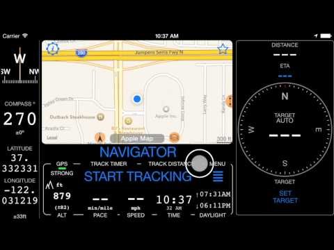
Compass 55. Land navigation mode
![]()
Land navigation is the base feature of the app. Working in both landscape or portrait modes it shows you:
GPS status indicator
If you have location enabled for the app this should show STRONG and being green within seconds under the open sky. GPS uses signal from satellites and thus you don’t need 3G/4G/LTE for the app to function. You can go to the airplane mode and still use the app, just don’t forget to download some maps if you need them when offline. If you are far away from any wifi and 3G networks or in airplane mode, please give GPS receiver up to 20 seconds to acquire the “lock” on satellites.
Here is how to troubleshoot GPS and location issues if indicator stays red even under the open sky
Compass
That’s either magnetic or GPS course based compass. Settings allow you to set either automatic switch between magnetic or GPS (the default) or you can set your preference to magnetic only (in case you mostly walk) or GPS only (in case you mostly drive). Compass can show you degrees or NATO mils (Compass settings).
When magnetic compass is used, value of its accuracy is also shown. When magnetic accuracy is worse than 15 degrees it is shown in the red font. To calibrate the compass wave with iPhone in 8 pattern until you see better accuracy values. In a car calibrated magnetic compass will lose its precision pretty fast, so you can consider either using the automatic compass mode or GPS course only when using the app in a car.
Current coordinate and location accuracy
Formats supported - Latitude/Longitude (decimal and degrees variations), UTM, MGRS with precision of 1 meter.
Map
Map can be native Google or Apple with support to street, satellite, hybrid modes and also extra Terrain, Night and “local paths” mode for the Google map. Both Apple and Google maps support showing traffic information.
You can download offline maps based on the built-in offline map providers or add your own online and offline providers for showing and downloading the maps.
‣ Avoid internet/data usage with a Blank Map
‣ Night and “local roads” styles for the Google map from version 1.1.
‣ Night mode auto switch for Google map from version 1.2
Altitude
Settings allow to set preference to feet or meters when you use nautical units.
Pace
Thats minutes you need to cover either mile, kilometer or nautical mile. Only shows when there is a GPS signal. Pace needs at least some time/distance tracked to show up.
Speed
MPH, KM/H or nautical knots. Only shows when there is a GPS signal.
Time
Settings allow you to set this to AM/PM or 24 hours format.
Daylight
Time of a sunset and sunrise. Uses GPS location to calculate and doesn’t need internet to show you the values.
Track distance and time
If you have tracking active these are showing you distance and time since the track start.
Arrow and distance left to the target
Use “SET TARGET” button to set the target via coordinates, on the map, by using the address or place name. The app will show you arrow to the target (also a line on the map between your current location and the target).
If tracking is active, estimated time to arrival will be shown.
Let me not complicate it here. Even without going further data above should be useful I hope whether you are getting to the camp in the forrest, fishing spot or just back to your car. Here are some more related links:
‣ How to retrace the previously recorded track?
‣ Tracks colored by speed or altitude.
‣ Color coded waypoints and tracks export to Dropbox or iCloud drive from version 1.3
Walk through the main functions