Version 6.3 - What's new?
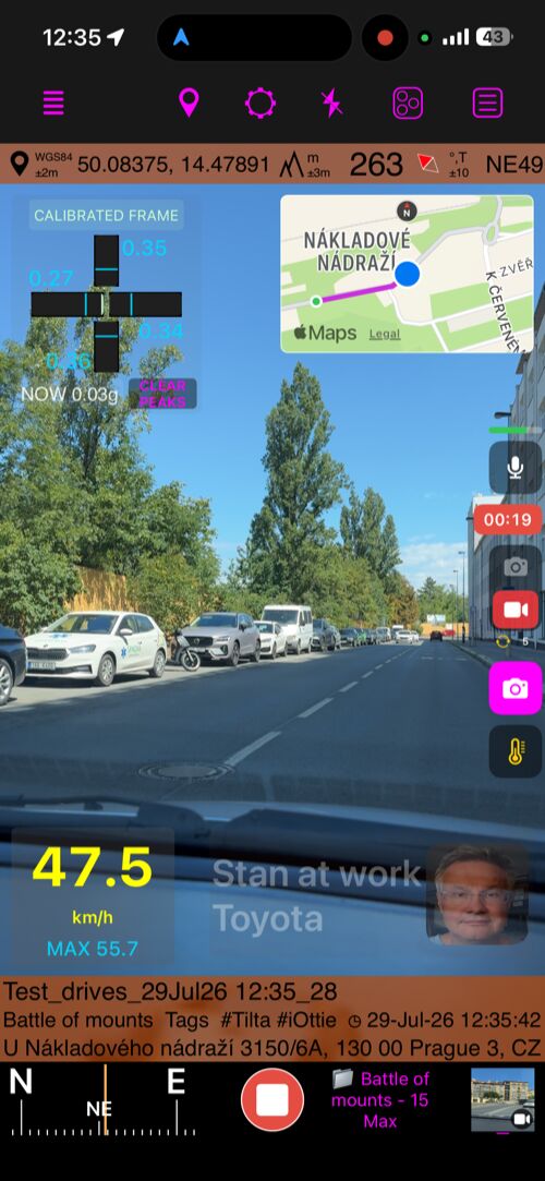
The road, the action, and the data—all in one recording (Free and Full versions)
Open the complete Video recording, replay, and data overlays guide.
- Turn the app into a dash cam for the drive or an action cam for the ride. Video, location, speed, and motion data stay together, giving every important moment the context behind it.
- See something worth keeping while the camera is rolling? Take a location-aware photo without stopping the recording or missing what happens next.
- Open saved recordings from MENU > VIDEOS and return to the exact moment you want. Use the photo shutter button during video replay to add that frame as a photo and waypoint with its location data—ready to keep, send to friends, or share on social media.
- Use the timeline to move quickly through the recording, then scrub left or right directly across the video for fine control and finding the exact frame.
- Share exactly what matters: export Full video or Selected range, then choose the untouched Original or a Stamped version with your chosen data overlays.
- To set up Loop recording, open the video camera, tap Settings, and choose Video settings. Then choose the loop duration—the amount of recent video to retain. Instead of filling storage with one endless recording, the app keeps only that latest window.
Make every recording tell more of the story
- Open the video camera, tap Settings, then choose Video overlays to build the dash-cam or action-cam view that fits your vehicle, activity, and story.
- Map: Keep the recording grounded in place during replay and in stamped exports.
- QR-Code: Use for export to turn any video frame into a direct link back to its location on the map or into navigation to that place.
- Watermark: Add your company name, logo, identity, vehicle, or equipment to the finished video.
- Speed: Show how fast you were moving and give action or dash-cam footage useful context.
- Pitch & Roll : Show pitch and roll in a car, lean and slope on a motorcycle, or pitch and bank in an aircraft—with wording and visuals you control.
- G-Cross : Capture acceleration forces throughout the action, calibrated automatically when recording begins.
Choose the right microphone for every recording
- Choose Automatic, iPhone, Any external, Wired / USB, or Bluetooth for video. The camera shows the active source, falls back safely if it disconnects, and can notify you when the microphone changes.
- Monitor the live microphone in headphones and keep compatible music or podcasts playing.
- During replay, see or change the active audio output while you review the recording frame by frame.
Speedometer 55 Free includes recording, replay, Loop Recording, microphone controls, and all data overlays. It stores one video and lets you share any selected 15-second clip with app branding; to record another video, open MENU > VIDEOS and delete the current one. For photos from video, watermark customization, unlimited stored videos, and full-length or clean-original exports, upgrade to Speedometer 55 Full PRO —a separate, one-time paid app.
Full version only
The remaining Version 6.3 features on this page are available only in Speedometer 55 Full PRO, the separate, one-time paid app.
Your track. Your important places. One complete story.
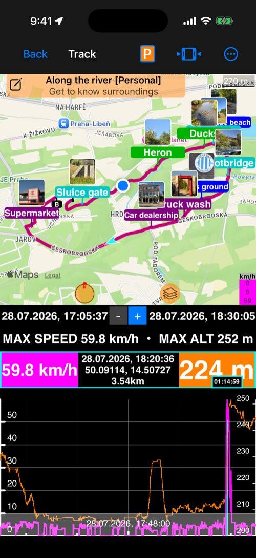
- Start recording a track and keep moving. Every waypoint you create along the way stays linked to that track automatically—so gates, hazards, viewpoints, samples, photos, and notes remain part of the journey that gave them meaning.
- When you review the track, show only its linked waypoints on the map—or bring every waypoint back for the wider picture. You can also link existing waypoints to any track, or unlink them.
- When the journey is ready to share or archive, export the track with its linked waypoints and keep the track and the places that mattered together.
Terrain elevation, right on the map
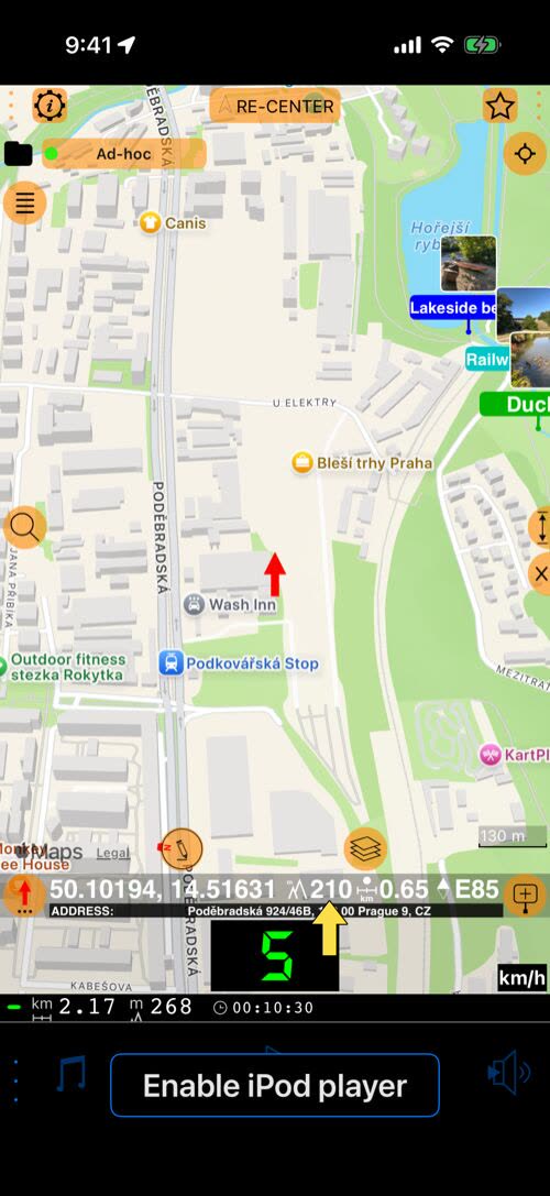
- Move the red arrow anywhere on the map and see the terrain elevation of that exact point, next to its coordinates, distance from you, and bearing.
- Check the height of a mountain pass, a viewpoint, or a landing field before you go there. Save it as a waypoint, and the waypoint keeps that height.
- Open the complete Map elevation guide.
Keep the map around every waypoint
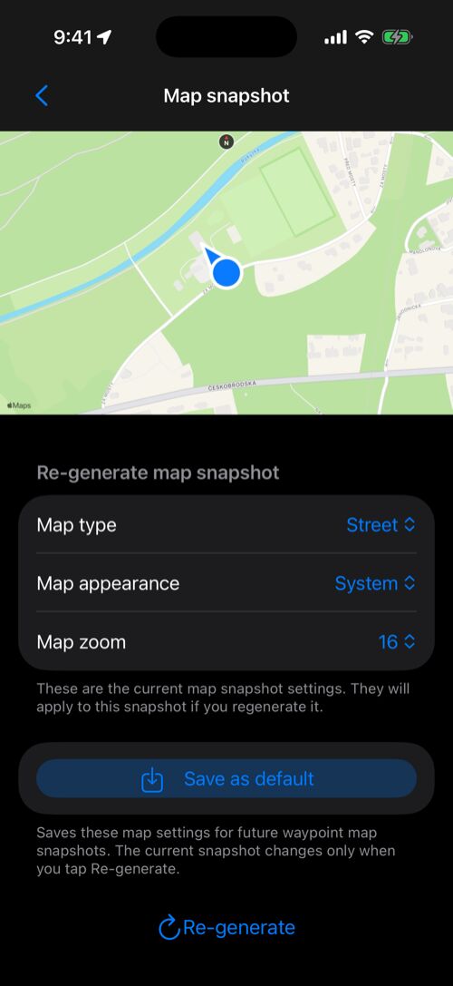
- A map snapshot preserves the surroundings of each waypoint for quick visual reference—even after you leave the place.
- To create a snapshot automatically for every new waypoint, open MENU > Settings > Advanced settings > Waypoint map snapshots and turn on Automatically create map snapshots. You can also add a snapshot manually whenever it is useful.
- In the waypoints list, use More to show or hide map snapshots and choose Waypoint row layout so photos, maps, and details work together.
- Tap a snapshot to open the larger view. Adjust Map type, Map appearance, and Map zoom, then tap Re-generate—or use Save as default to keep those choices for future snapshots.
- When several waypoints need the same updated map appearance, select them and choose Generate map previews to update their snapshots as a batch.
- Open the complete Waypoint Map Snapshots guide.
Export tracks with their waypoints
- Export a recorded track with its linked waypoints in one KML/KMZ file, keeping the route and the places that mattered together.
- Import combined files as tracks only, waypoints only, or everything. Links stay intact, and the track line and Start/End pins are not re-imported as duplicate waypoints.
- Track times, speeds, distance and altitude summaries, map snapshots, and GPS accuracy survive the round trip.
❤️ Enjoying the app and its updates? Please consider leaving a rating—it means the world to us!
Ready to keep the whole journey—not just a short highlight? Upgrade to Speedometer 55 Full PRO —a separate, one-time paid app—lets you store unlimited videos, export full-length or clean-original files, customize your watermark, and create photos and waypoints from replay.
