Course notes — the road book that follows your distance
Course notes are the road book inside the app. Each note is bound to a distance from the rally start, so the next instruction appears by itself as you drive — no tapping, no page turning, and it stays correct after you correct the odometer.
On the panel while you drive
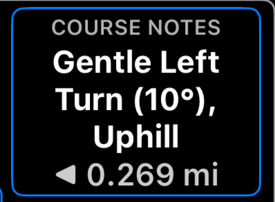
The rally control panel shows the next instruction big, and the distance still to go with the marker in the status line. When a rally has no segments, the notes take the freed space on the panel, so the gauges stay available for distance, timer and averages.
Before the start the same area shows the event identity and the first note, so you can confirm you loaded the right rally book.
You can also add a Course notes gauge to the rally gauge grid, and tapping the notes opens the full list.
The list
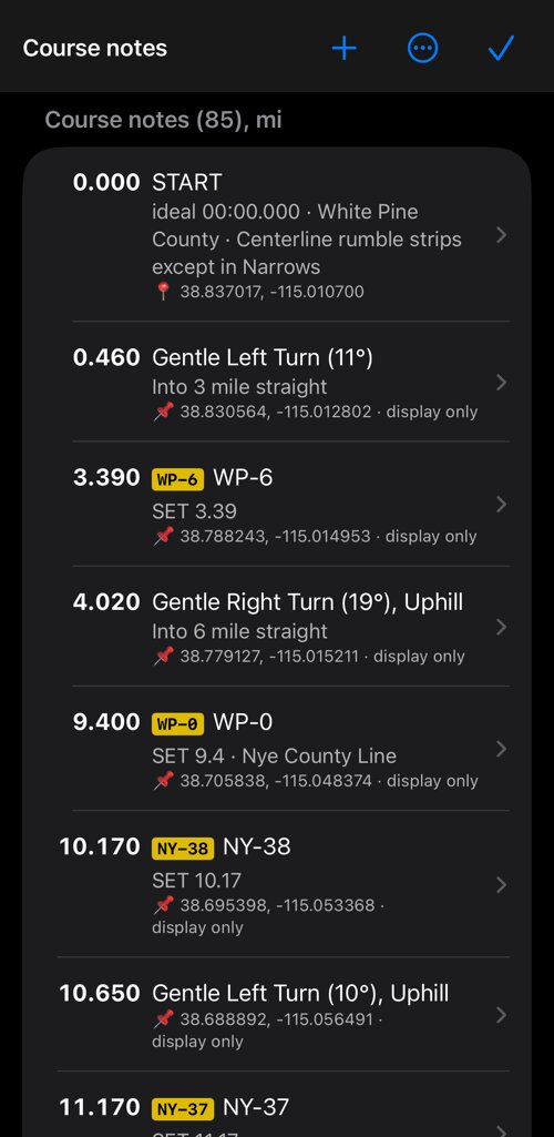
Open Rally settings > Course notes. Each note has:
- Distance — where it applies, in the rally’s units.
- Marker — the optional mile-marker or landmark badge, such as
NY-38. - Instruction — the description:
Gentle Left Turn (11°),Checkpoint #2 · flags on RIGHT. - Remark — the secondary line:
Into 3 mile straight,SET 10.17. - Location — optional coordinates.
Notes stay sorted by distance. Tap one to edit it, swipe from right to left to delete it, and use + to add one. The ⋯ button clears them all.
Read aloud
Voice callouts are on by default: a loaded book reads each note aloud before you reach it, so a driver working alone never has to look down. The app speaks the whole note — marker, instruction and remark. In Session options you can turn them off, and set how far ahead the next note is read.
Location and odometer sync
A note may carry coordinates. That does two things, and they are deliberately separate:
- On the map — the note appears on the route map and in the map gauge, so you can see where it is.
- Snap the odometer here — when you pass the place, the rally distance is corrected to that note’s distance. This is what keeps a GPS odometer honest against official mileage over a long stage.
Because a GPS odometer drifts, snapping should only happen at points whose position you trust. Turn Snap the odometer here off for approximate positions and keep it on for surveyed ones — checkpoints and official coordinates. In the list, 📍 marks a note that snaps and 📌 marks a location that is shown but does not touch the distance.
Anchor behaviour and the anchor radius are in Session options under Geo anchors.
Pick the place on the map
Instead of typing coordinates, tap Pick on the map under Location (optional) in the note. Move the map until the crosshair sits where the note belongs; the route and your other located notes stay in view for reference.
- When the book has a route, Snap to the route pulls the crosshair onto it within 250 m and shows the distance from the start. Confirming fills in the coordinate and the note’s distance.
- With Snap to the route off, or farther than 250 m from the route, only the coordinate is filled in and the distance stays as you typed it; the screen says how far from the route the crosshair is.
- On a route that passes the same place twice, the note’s current distance decides which pass it snaps to.
- Without a route, only the coordinate is filled in.
Where course notes come from
- A rally book you load or import brings its notes with it.
- Rally settings > Add waypoints or a track to the rally turns a waypoint collection into course notes, and Route → navigation notes turns the turns of the rally’s route into notes.
- The route editor makes notes from handles: a waypoint you add as a handle, or a handle you give a note, becomes a course note at the exact distance the route reaches it. On Apply it also offers the route’s turns as notes, with or without tulip diagrams.
- You can type them in by hand with +.
Related:
Rally book ▪︎ Rally computer ▪︎ Route editor ▪︎ Route map ▪︎ Session options
