Version 4.4 - What's new?
Video recording, with location data built in

Prepare the survey view, confirm the microphone and overlays, then tap the shutter to start recording.

Open the complete Video recording, replay, and measurement data overlays guide.
- Document inspections, surveys, sites, and observations with video that keeps its location data attached. When the work calls for movement, the same recorder is ready to capture the action without losing the field context.
- Need to preserve a specific detail? Take a location-aware photo while recording continues, then carry on with the survey.
- Open saved recordings from MENU > VIDEOS and return to the exact moment you need. If you missed or forgot to document an important place, use the photo shutter button during video replay to add that frame as a photo and point—with the location data from that moment.
- Use the timeline to move quickly through the recording, then scrub left or right directly across the video for fine control and finding the exact frame.
- Share exactly what matters: export Full video or Selected range, then choose the untouched Original or a Stamped version with your chosen data overlays.
Make every recording tell more of the story
- Open the video camera, tap Settings, then choose Video overlays to match the record to your survey, site, equipment, or field workflow.
- QR-Code: Use for export to turn any video frame into a direct link back to its location on the map or into navigation to that place.
- Watermark: Add your company name, logo, identity, vehicle, or equipment to the finished video.
- Speed: Show how fast you were moving and give action or dash-cam footage useful context.
Planimeter 55 Free stores one video and lets you share any selected 15-second clip with app branding. To record another video, open MENU > VIDEOS and delete the current video. The in-app
PRO PACK upgrade
unlocks unlimited stored videos and full-length or clean-original exports.
Keep the map around every point

- A map snapshot preserves the surroundings of each point for quick visual reference—even after you leave the place.
- To create a snapshot automatically for every new point, open More > Point map snapshots and turn on Automatically create map snapshots. You can also add a snapshot manually whenever it is useful.
- In the points list, use More to show or hide map snapshots and choose Point row layout so photos, maps, and details work together.
- Tap a snapshot to open the larger view. Adjust Map type, Map appearance, and Map zoom, then tap Re-generate—or use Save as default to keep those choices for future snapshots.
- When several points need the same updated map appearance, select them and choose Generate map previews to update their snapshots as a batch.
- Open the complete Point Map Snapshots guide.
Terrain elevation, right on the map
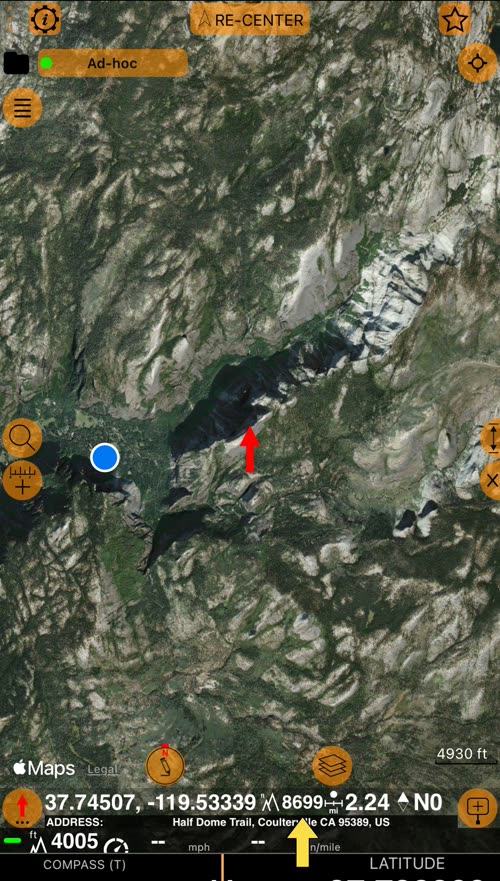
- Move the red arrow anywhere on the map and see the terrain elevation of that exact point, next to its coordinates, distance from you, and bearing.
- Compare the corners of a field or a plot to see which way the land falls. Add a point at the arrow, and the point keeps that height.
- Open the complete Map elevation guide.
Points-only KML/KMZ export and import
- Export and import points in KML/KMZ, keeping their photos, notes, and location details together.
- Map snapshots and horizontal/vertical GPS accuracy are preserved with each point when available.
- For points with drawings, choose a presentation KMZ or a KMZ with editable drawings when you need to continue editing later.
❤️ Loving the app? Your rating makes a huge difference. Please take a moment to leave one — it means the world to us!
