Land navigation mode
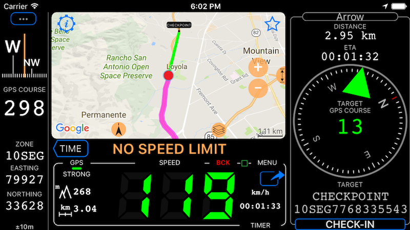
Arrow pointing to your target (and line on a map), compass and coordinate.
Setting the target.
When no target is set, the arrow area will show “SET TARGET” button. Use it to set the target either based on existing waypoint or by creating a new one.
If GPS tracking is not active when you start the target navigation, the app will ask if you would not like to start tracking.
Arriving at target, check-in.
Use CHECK-IN button in the arrow area to stop navigation to the target and if track recording has been active, the app will prompt you to either continue it or stop.
Changing coordinates format.
You can show coordinates of both current and target location in lat/long, UTM and MGRS formats. Additionally you can choose between degrees, Dm and Dms formats for latitude and longitude.
Advanced Settings > Coordinates format provides you with these options.
That green line to the target on a map.
All maps support showing a green line to the target. This is especially handy when you use full screen map and arrow area is hidden. Following the green line will lead you to the target.
Hold your finger on a map to open options to show or hide the line.
This feature is available only in the full version. You can upgrade by tapping here.
All modes: Default mode ▪︎ Waypoints monitor (e.g. speed cameras) ▪︎ Rally computer ▪︎ Taximeter ▪︎ Map ▪︎ Heads up speed display ▪︎ Full screen speed display ▪︎ Full screen map display ▪︎ G Force acceleration monitor ▪︎ Land navigation mode ▪︎ Idle timer and alert mode ▪︎ Water sports boat mode ▪︎ Paragliding mode