Speedometer 55
Essentials:
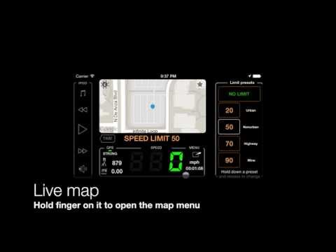
- GPS tracking
- Offline maps ▪︎ Map collections ▪︎ Ground image overlays
- Driving cost monitor ▪︎ Fuel and driving range monitor
- Mileage calculator ▪︎ Reconstruct a mileage log for taxes or reimbursement
- Channels — go live, solo or with the group.
- Rally computer
- Voice coach ▪︎ Siri and Shortcuts to control the app and speed limits.
- Infotainment
New and worth mentioning:
Version 6.1 (June 2026)
Track together: introducing Channels — plus an adjustable active track line width.
Version 6.1 details (tap to expand)
- Channels
— go live, solo or with the group. Channels replace GPS Beacons. While tracking, share your live location through a private web link (with optional password protection), or inside a shared group channel where members follow each other directly in the app or on the web. Join an existing channel, or create your own and invite others to follow or participate.
- GPS Beacons users: your capability didn’t go away — it grew. Everything a beacon did, Channels now do, plus group following.
- Pitch & Roll Panels
- Added motorcycle graphics — switch between the default car and the optional motorcycle image in the panel settings (3-dots menu → “All settings”).
- Added an airplane image option.
- Fixed panels incorrectly using the same rear vehicle image on iOS 15.
- Voice Guidance
- Added a new option in General Sound Settings to explicitly select which device voice is used for voice guidance and announcements.
- Voice Coach and Navigation Hints
- Voice Coach and navigation hints now work together in one clearer setup. Configure regular coach announcements, on-course guidance, spoken target distance and bearing, and relative or absolute spoken bearings from the same place.
- Voice Coach can now include target navigation guidance in regular time or distance interval announcements, telling distance and bearing to the current target when one is active.
- New absolute spoken bearing guidance lets you keep the iPhone in your pocket and navigate by voice hints while holding a magnetic compass in your hand.
- Huge thanks to Steve for suggesting absolute bearing voice guidance and testing it in the wild.
- Maps and Tracks
- Active tracks are now always displayed above pinned tracks for better visibility while navigating.
- Fixed the Course line that could disappear after sending the app to the background and returning to it.
- Set how thick the active track appears on the map in Map Settings → Common Map Settings → Active Track Line Width. The thinnest width is now the default for better map visibility.
- Import & Export
- Improved KML and KMZ export/import with better compatibility and more reliable fallback handling for point descriptions and notes.
- Other Fixes
- Fixed an occasional crash in the export file name pattern editor on iOS 17.
- Fixed a very rare crash on iOS 15 when applying filters in the Trips & Tracks list.
- Fixed an issue where bottom action buttons were not shown for selected waypoint collections on smaller screens in iOS 26.
Version 5.9 (April 2026)
Expanded motion analysis, mapping, and trip management — including EV cost tracking, multi-track pinning, online map caching, a reworked trip editor, and new Pitch & Roll and G-Force visualization tools.
Version 5.9 details (tap to expand)
- Reworked trip editor to streamline initial mileage setup and ongoing trip counter management (set/reset total and current counters).
- EV support : cost, consumption parameters, and driving range. Track cost is now based on the cost parameters saved with the track at completion, not the current settings.
- Pinned tracks upgraded : add multiple pinned tracks to the map (no longer limited to one). Customize color and line width, save pinned sets as presets, and apply them when needed.
- Online source map cache : tiles are now cached to improve map browsing and reduce mobile data usage and load on map providers.
- Pitch & Roll mode: central and micro panels to improve spatial awareness and safety (off-road limits, motorhome balancing, etc.). Includes customizable alerts for unsafe angles and recovery back to safe ranges.
- G-Force mode (reworked): central and micro panels now feature G-Bowl alongside the G-Force graph. Includes customizable alerts for overloads on any axis. Measure your limits — and choose whether to stay within them or push beyond.
Version 5.8 adds:
- Ability to rename track categories (Settings > Advanced > GPS Tracking > Customize category names) to match your activities or business.
- Ability to set distinct remuneration/tax refund amounts per category before generating the PDF mileage report.
Soon:
Version 6.2 (Early July 2026 or late June 2026)
Waypoint Map Labels: Adjustable Size, Backgrounds, and Photos
Version 6.2 details (tap to expand)
- Waypoint labels, your way
- Waypoint names can now be shown as compact or larger map labels, with either the current filled background or a clean no-background style using the waypoint color for the text.
- Waypoints with attached photos can show a thumbnail right above the name on the map, making photo points easier to recognize without opening the waypoint first.
- To set it up, open Map Settings > Common settings > Waypoint labels. Label size, Photo thumbnail, and Label background are separate visible controls.
Version 6.2 is available as the public beta version
Available in public beta (release date TBD):
- G-Cross mode and G-Bands panels for alternative visualization and analysis of acceleration trends and peak values.
- Road Survey and Camera Rig utilities within the new Motion Quality mode.
Designed for measuring road quality or tuning your camera rig (or any mounted device) for safety, comfort, and stability. - Resonance Scan mode — for dialing in custom setups and identifying vibration and resonance behavior.
These features are currently available only in the public beta while we refine them together with beta users before the App Store release.
TROUBLESHOOTING
- No speed is shown and GPS indicator is red. Help!
- How to switch to MPH or Knots
- App shows different speed than my car’s speedometer shows. Why?
- There is no sound alert on exceeding the preset limit. Help!
- I’m at sea level and app shows 80ft (around 25 meters) or more. Why?
- Compass works really oddly, stays at North and then jumps to South. Help!
Configuring and troubleshooting: alerts , sound
We answer every support email! Please use MENU > Feedback & Support > “Email developer” button after tapping on a star button.
You can access the app developer (Stan Dvoychenko, me) directly via email: support@blocoware.com or phone +420 724 730 447 (+iMessage). But I’d prefer you contact me via the star button as I’ll have extra information on the iOS version and device model in this case.
Tips & Tricks
– FREE AND FULL VERSION –
- Show trip timer in the main GPS panel
- I can change preset limit values, right?
- Where is that GPS black box?
- What’s that Heads-up (hud) screen?
- Can speedo run on my iPad side by side on a screen with other apps (iPad multitasking)? Yes it can!
– FULL VERSION –
- I want speedo to work in the background, so it alerts me even when screen is locked or I’m using other apps!
- I need more speed limits !
- Siri voice shortcuts for tracking and speed limits help to keep your hands on the wheel and eyes on the road! + give you more than 8 speed limits!
- I need different speed digit colors!
- Hey speedo! Show me the cost of my driving!
- I want speedometer to alert me on 30mph when I have speed limit set to 25! How?
- How to show speed with decimal precision?
- Speedo is too bright at night. Night mode please!
- Show trips stats, weather, wind conditions and forecast when I wait on red light or in a jam
- I need to record GPS tracks!
- How to retrace the previously recorded track?
- Can speedometer remember speed limits for me? (Hint: Yes it can:))
- I’ll go off the grid! Let me download offline maps!
- Avoid internet/data usage with a Blank Map.
- Fuel indicator in my car/boat doesn’t work and I want to monitor a driving range between refuels !
- As a pilot I need to see altitude in bigger numbers and units (feet/meters) of my choice!
- Reset individual counters only (e.g. max and average speed), reset total counters, or set distance to some initial value (e.g. ODO in my car)?
- Voice coach to tell distance and time tracked, plus current speed and altitude values at configured time/distance intervals.
- Show me vertical speed.
Modes
Free and full versions:
Full version only:
- Waypoints monitor (e.g. speed cameras)
- Rally computer
- Taximeter
- G-Force acceleration monitor
- Land navigation mode
- Idle timer and alert mode
- Water sports boat mode
- Paragliding mode
- Bluetooth sensors: Heart rate, Cycling speed, cadence
Recording tracks and keeping mileage records
- GPS tracking
- Track categories for reimbursement/reporting (business, personal, etc).
- Customizable PDF mileage reports for reimbursement.
- Mileage calculator - estimate costs and generate mileage records without having to drive!
- Reconstruct a mileage log for taxes or reimbursement - rebuild past records and keep them audit-ready.
- Automatic mileage tracking for automotive activities, optional.
- Work hours schedule for automatic driving tracking.
- Using iBeacon for more precise automatic tracking start and stop
Remember speed limits
Allows you to apply speed limits once as you drive and let speedometer re-apply them for you the next time.
Complete showcase video , text manual , and troubleshooting speed limit memory function .
Waypoints. Speed and red light cams
Short video tutorials: Drive , Setup , Edit , Import/Export .
Text manuals:
- Waypoints and POIs import
- Waypoint/POIs alerting
- Edit waypoint/poi type, course, speed limit, approach type
- Details and troubleshooting for alerting on speed cameras
- Add waypoints/cameras as you drive
Information for scdb.info users
Maps
Show me the map! ▪︎ Google map night mode
Maps user manual ▪︎ Offline maps ▪︎ Custom map sources
Map collections , allowing you to build a custom map setup—from the base map to a configurable set of map and image overlays—tailored to your mission. Switch between map collections with a single tap when your task demands it. From version 5.5.
Maps video tutorial (full screen, offline and custom)
Import existing mbtiles, Rmaps, sqlitedb maps
Convert your existing map (e.g. GeoTiff or PDF) into a format supported by the app
Overzoom and underzoom handling for the offline maps
Grid shows instead of an offline map, help!
Heads-up (HUD) and full screen modes
HUD - heads up or reflection mode. Tell me more!
Heads-up and full screen in version 1.6 - video review
Waypoints
Version 4.9 with new coordinates converter for the waypoints editor and the map search by coordinates.
Measuring altitude and vertical speed
- Paragliding mode
- Barometric altitude or height (QNH + QFE)
- Barometric reference/calibration
- Vertical speed indicator + Compass
- Barometric vertical speed indicator
Cost, fuel, driving range
LAND NAVIGATION
Route navigation with voice guidance
Route editor and GPX route import, from version 1.7
You’ll find land navigation settings such as using average or instantaneous speed for ETE or using relative or absolute course to target in Settings > Advanced Settings > Land Navigation.
BLUETOOTH SENSORS INTEGRATION
Bluetooth sensors integration: Heart rate, cycling speed, and cadence .
Additional customizations
Version 4.8.1 with options to customize button colors in the app. This should provide more options for improved visibility of buttons in bright sunlight and potentially assist in cases involving color vision deficiencies.
Version 1.9.10 with customizable screen corners .
Manuals and articles
Built-in iPod player - User manual
Replay tracks and show elevation/speed profile in Google Earth on PC/Mac
Video tutorials
BASIC FEATURES. FULL VERSION 1.5.3
Sit back and watch! All video tutorials as a YouTube playlist
Download the full speedometer version!
Other apps that you can take from our garage for a ride:
GPS Camera 55. Capture photos stamped with location, direction, and notes.
![]()
Off-road navigation and compass app: Land, Air, Marine.
![]()
GPS Team 55 - Team tracking and collaboration.

Docs ▪︎ Free in AppStore ▪︎ Public beta version (free)
Professional GPS taximeter.
![]()
Planimeter 55. Measure area, perimeter, distance.
You can access the app developer (Stan Dvoychenko, me) directly via email: support@blocoware.com or phone +420 724 730 447 (+iMessage). But I’d prefer you contact me via the star button as I’ll have extra information on the iOS version and device model in this case.
Recent releases not mentioned in the new and worth mentioning.
Version 6.0 (May 2026)
Intermediate stops to mileage and cost estimates, more natural automatic voice guidance with smarter handling of numbers and time across all languages.
Version 6.0 details (tap to expand)
- Mileage and Cost Calculator
- Add intermediate stops to your estimates, making them more precise and useful for cost planning, reimbursement records, and tax reporting.
- More Natural Voice Guidance
- Navigation hints, voice coach announcements, and waypoint proximity alerts now use the best available voice automatically, with improved handling of plurals, decimals, numbers, and time or duration announcements across all supported languages.
- Trip Tracks and Offline Maps
- Fixed track numbers not being shown on the map when viewing all tracks for a trip. Start and end markers now match the track numbers from the trip track list.
- Pinned tracks can now be shown on the offline map download screen, giving better spatial awareness when choosing which region to download.
- Drawing Tools for GPS Camera and Ground Overlays
- GPS Camera drawing tools received a major update with text, dimension, and selection tools.
- The new drawing tools and options can now also be used when editing ground map image overlays.
- Drawings are no longer hardcoded into photos or ground image overlays on save, so they can be edited later.
- Import Fixes
- Improved error handling when importing incomplete or corrupted trip archives.
- Fixed GPX import so the import options page closes correctly after import, and the Cancel button works as expected.