Compass 55. Breaks in a track: see your pauses and your GPS reception
Where did I pause? Where did the GPS lose reception, and for how long? A track now tells you. Every recording keeps its breaks: the pauses you took, the stretches where the GPS had no position, and any time the app was not running. The map and the chart show them, so you can read the ride as it really happened, and the climbs and totals are computed only from what was actually measured.
Three kinds of break
| Break | What happened | Time | Distance |
|---|---|---|---|
| Pause | You paused the track, and resumed it. | Counted as paused, not in the total time. | None: what you covered while paused is not added. |
| GPS lost | No accurate position for more than 10 seconds: a tunnel, a building, a dense forest. | In the total time, but not in the moving time. | The straight line between the last position and the next one. |
| App closed | The app was not running for a while in the middle of a track, for example swiped away in the app switcher. | Not counted: the app was not there to record it. | The straight line between the last position and the next one. |
The app notices each break by itself while it records, and keeps it with the track: in the track’s files, in GPX and KML exports, and back again when you import them.
Tip: leave the app running while you record. The track goes on in the background, with the screen locked or another app in front. Swiping the app away in the app switcher stops the recording until you open the app again; the track then continues, with an “app closed” break in between.
On the map
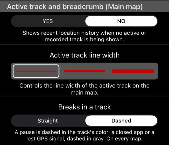
Choose how breaks are drawn in Map settings → Active track and breadcrumb (Main map) → Breaks in a track (long-press the map to open Map settings ):
- Straight (the default): the track runs straight across a break, as it always did.
- Dashed: the track’s line stops at a break, and a dashed line joins the two ends, so you see at a glance which part you rode and which part was not recorded. A pause is dashed in the track’s own colour; a stretch without GPS or with the app closed is dashed in gray.
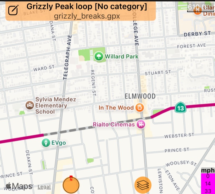
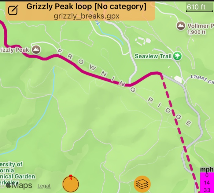
The setting applies to every map: a recorded track you open, your pinned tracks, and the live track while you record.
On the chart
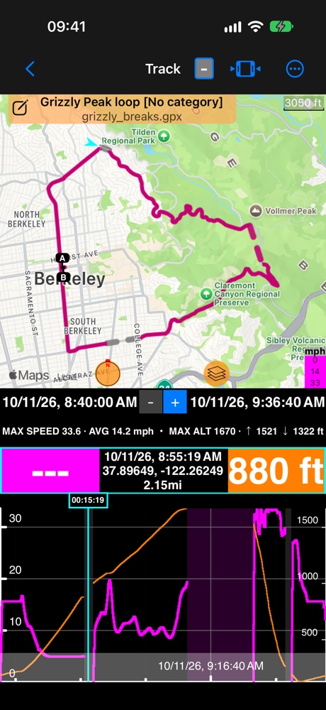
The track’s chart marks every break with a band, so each gap in the lines has its reason:
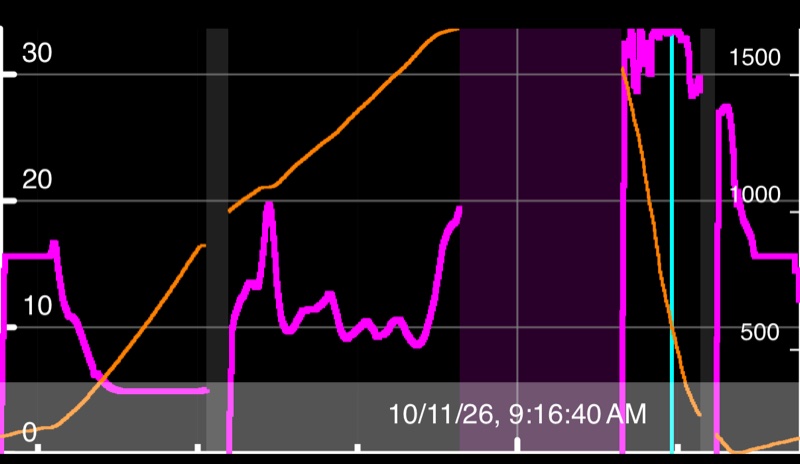
| Band | Means | Speed box inside it |
|---|---|---|
| Gray | No position: the GPS lost reception, or the app was closed. | “—” |
| Light magenta | A pause: you paused the track. The same colour the map uses for a pause. | “—” |
| none | Recorded: the lines show what was measured. | the speed at the cursor |
On the time axis a band is as wide as the break lasted; on the distance axis, as wide as the ground it covered, so a stop shows only as a thin line there.
- Altitude is dashed where nothing was measured: across a stretch without GPS, and wherever the GPS altitude was too uncertain to trust (indoors, say). There the line runs level at the last height the app could trust, instead of plotting a wandering height.
- The lines stop at a break and start again after it: at a pause, at the app closed, and at a GPS loss that covered ground. A short loss without much ground, a stop in a shop say, is a band with the line running through it.
The recorded statistics (MAX, AVG, ascent) are not changed by any of this: they are what the recording measured.
On the live Climb profile
The Climb panel’s profile of the road ridden ( Climb ) uses the same look while you ride: the line is dashed and the ground under it gray over a stretch without a position or without a trusted altitude, with the band where the GPS was lost. While it is still going on, a short band at your end of the profile shows it, and your dot dims until the next position.
Climbs and totals
- A climb stops at a pause or the app closed, and at a GPS loss that covered ground (150 m or more), and a new one can start after it. Standing still is no break: a climb survives a stop, with or without a position.
- Gradient and the steepest 100 m are only measured on road that was recorded, never across a break.
- Ascent: a pause or the app closed adds nothing across it; the height starts again from where you go on. Across a GPS loss the app adds only a cautious estimate of the height gained, not the whole difference.
- MOVING time never counts a break. TOTAL time counts a GPS loss, but not a pause or the time the app was closed.
Related: GPS tracking ▪︎ Track data ▪︎ Map settings ▪︎ Climb ▪︎ Where were the climbs on my ride?